|
The Rural Scene in Etwall and Burnaston
A guide to the area’s geography
Locations to Visit
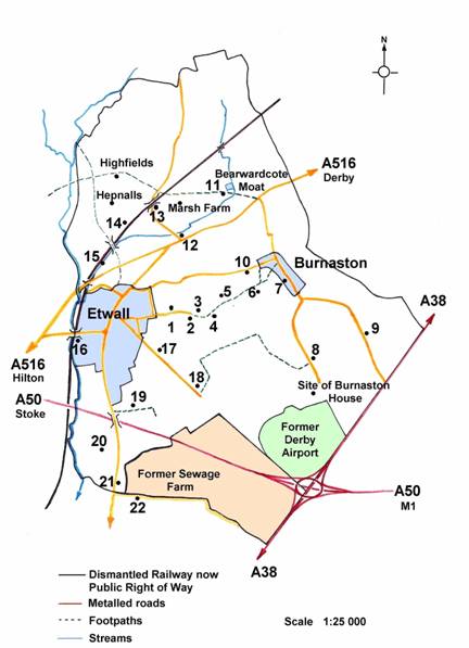
Numbered locations are marked on the map. All are on public footpaths or minor roads and they present selected aspects of the rural scene within the parishes of Etwall, Bearwardcote and Burnaston. Any sequence can be followed. The Ordnance Survey 1:25,000 Explorer series 259 will be helpful.
Introduction
The dominant local rock beneath the undulating landscape of Etwall, Burnaston and Bearwardcote is Mercian mudstone, a, red clay or marl which gives stiff soils that drain poorly and tend to acidity.
During the later stages of glacial episodes the melting ice sheets deposited sand and gravel in the Dove and Trent valleys at depths of up to 10 metres. An extensive area of these deposits occurs in the south of Etwall and Burnaston parishes and north of Egginton. To the end of the eighteenth century this was common land known as Egginton Heath.
Lesser deposits of glacial sands are found on higher ground in the vicinity of Etwall village while Etwall Brook and its tributaries are bordered by floodplains.
Etwall, Burnaston and Bearwardcote have been settled and farmed since Saxon times. All three feature in The DomesdayBook of 1086 as Etewelle, which could be Eata’s spring or perhaps the ‘et’ or meadow by the spring, Bernulfestun, meaning the ‘ton’ or farmstead of Bernulf’, and Berewards Cote, possibly the bear keeper’s ‘cote’ or cottage.
In the middle ages, land was not owned as it is today. Open fields were cultivated communally in strips and areas of meadow and common were shared. From the fourteenth century the open fields were gradually ‘enclosed’, that is they were converted into hedged fields, held by individual farmers. The final stage of this process took place in both Burnaston and Etwall following the Parliamentary Enclosure Act of 1797 when the remaining open land (see map) was enclosed. The largest areas involved were the gravel lands of Etwall and Burnaston Commons, both parts of Egginton Heath, which was first mapped by Burdett following his commission to map Derbyshire in 1762. Burdett's Map also shows that the outline of the present landscape of villages, roads and farms was clearly established.
Parliamentary Enclosure required the survey and redistribution of the newly defined fields, often in proportion to the historic common rights of individuals affected. For some an acre or so might substitute for keeping a cow and cutting furze on the common while William Cotton of Etwall Hall received 314 acres as Lord of the Manor.
Following the sale of the Cotton estate in 1827 local farmland passed into the hands of relatively small local owners and former tenants. The largest of which was Etwall Corporation, which administered the Etwall almshouses and was not part of the local government system. At this time specialist dairy farming prevailed in the locality with much land put down to pasture. The former commons remained arable for a time but were destined to become a sewage farm in 1895, an airfield in 1936 and in 1989 the Toyota car factory. In the 1990s the A50 trunk road was built across the southern end of the common.
Along Sandypits Lane and the Burnaston Field Path
1.Sandypits Farm, recently renovated, dates from the early nineteenth century. The name derives from pits, noted in 1811, in the sand deposit capping the ridge leading east out of Etwall. In the nineteenth century it was a dairy farm and sent milk to London after the opening of Etwall Station in 1878.
The area between Sandypits Lane and Burnaston Lane, shown as Windmill Lane and Slade Field Lane on the 1798 map, was known earlier as Slade Field. This was one of the open arable fields cultivated in strips and reduced in extent by the early enclosures. ‘Slade’ indicates the poorly drained character of the land stretching from the foot of the slope out beyond Burnaston Lane and merging into Etwall Marsh, which was centred on what is now the roundabout at the eastern end of the bypass.
2. The pond probably marks the site of a clay pit dug in the marl formation. The tithe survey of 1849 indicates a brickyard here occupied by John and Robert Platts of the workshops in the row of buildings where Etwall Post Office now stands.
3. The rise above the current Blenheim Farm buildings was shown as Marlpit Hill in 1797 and was the site of an early windmill, adjacent to another open arable field shown as ‘Windmill Field’.
4. Old Lodge Nursing Home was Etwall Hospital before the site’s redevelopment in the 1980s. The frontage of the main building has not been much modified. Founded in 1902, it was an isolation hospital for infectious diseases including tuberculosis. The south facing site would have facilitated the fresh air treatments then in vogue. Later it offered physiotherapy and care for the terminally ill. It was closed gradually between 1980 and 1988. Risborrow Close is on the site of the hospital grounds and named after the Risburrow fields, identified in the thirteenth century records of Welbeck Abbey and in the 1798 Enclosure Survey. ‘Risburrow’ is thought to mean ‘sandy rise pastures’.
5. There was a Royal Observer Corps Post here during the second world war, the extensive views making it ideal for monitoring aircraft movements. Today, a good feel for the local landscape can be obtained from the field path. To the south the Toyota Factory is screened by extensive landscaping. To the east Burnaston village straddles a north - south ridge while to the north behind The Seven Wells the former railway track, now part of the National Cycle network can be made out.
The large pit to the north of the path, mapped by the Ordnance Survey in 1881, was probably dug for clay for marling. Marl sub-soil was often spread on the land as fertiliser until the early nineteenth century when better transport made lime more widely available,
In and Around Burnaston
6. Toward Burnaston along the footpath, Little Field was enclosed following the Act of 1797, the straight hedged boundaries visible to the south being determined at this time. The ridge and furrow seen here is evidence of open field strip cultivation fossilised when land was put down to grass. It was fashioned by medieval ploughmen who worked their strips by turning the soil inwards from each side to form a ridge. Drainage was improved as ridge and furrow is often orientated down the slope. Throughout the Midlands it is typical of heavier lands now in grass.
7. Burnaston village was much redeveloped during the later twentieth century but the original form of a through road bordered by farms plus outbuildings and cottages is still discernible. The Brick Farmhouses, dating from the eighteenth
 and nineteenth centuries, were of a size to accommodate the farm family as well as indoor servants, dairymaids and unmarried agricultural labourers. and nineteenth centuries, were of a size to accommodate the farm family as well as indoor servants, dairymaids and unmarried agricultural labourers.
Most significant of the early buildings are the Homestead, originally a timber-framed labourer’s cottage, and Burnaston Old Hall on the Etwall Road, an elegant eighteenth century dwelling.
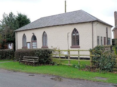
The Village Hall was built in 1839 as a chapel for protestant worship on land owned by Arthur Minton who also built the Methodist Chapel in Etwall. It was leased to the Primitive Methodists in 1874. A Sunday School was held in the early twentieth century and services were conducted by the Vicar of Etwall from 1957. It became the Village Hall in 1974.
8. At the north end of the ridge on which Burnaston is located and beside the field path towards Mickleover there is a complex of medieval earthworks, including a hollow way and two house platforms which suggests that some of the settlement area may subsequently have been abandoned.
9. Following the enclosure award of 1798 the remaining areas of open land around Burnaston village were laid out as fields with straight hedge lines. These were the fragmented Riding Field, Top Meadow Field, Little Field, Town Meadow and Burnaston Common. Former tracks which led to the Derby turnpike, now the A38, were also straightened and defined by ditches and hedges forty feet apart.
About 400 yards south of the Toyota Plant boundary stood Burnaston House, demolished to make way for the factory. It was built by A N E Mosley in 1824 at just within Etwall Parish. It was his residence on the estate he created in the southern parts of Burnaston and Etwall.
In 1936 the land south of the house was purchased by Derby Corporation for development as a grass surfaced airport but was soon adapted for flying training during the Second World War. After 1945 it was used commercially until 1961 and then for club flying until its purchase in 1989 by Toyota.
10. South of the lane from Burnaston to Etwall the fields show good examples of ridge and furrow with a slight but discernible reversed ‘S’ form believed to result from the way medieval plough teams were swung onto and off a strip. The field boundaries also follow the curved shape of the strips.
Between Bearwardcote and Etwall Station
11. Bearwardcote Moat, now overgrown and inaccessible, marks the site of a medieval manor house. It was the key feature of this small township, which seems always to have consisted of a few scattered dwellings. The house was demolished in 1790 by a new owner, Robert Newton of Mickleover, whose descendant, the Derby banker Leper Newton, built nearby Bearwardcote Farm in 1886.
 12. The Seven Wells is beside the site of the former cheese factory promoted in the 1870s by Leper Newton, who owned much of the land north of the present A516. Newton was responding to the initiative of Lord Vernon of Sudbury to establish small cheese factories served cooperatively by local farmers to make cheese of a quality to compete with the imports from America. The factory was soon sold to Brettles, the Leicestershire makers of Stilton cheese. 12. The Seven Wells is beside the site of the former cheese factory promoted in the 1870s by Leper Newton, who owned much of the land north of the present A516. Newton was responding to the initiative of Lord Vernon of Sudbury to establish small cheese factories served cooperatively by local farmers to make cheese of a quality to compete with the imports from America. The factory was soon sold to Brettles, the Leicestershire makers of Stilton cheese.
The site became Etwall Garage in the twentieth century and that in turn ceased trading in 2006.
The land by the stream in the vicinity of The Seven Wells has long been known as Etwall Marsh. In 1557 John Port II left money in his will to raise the level of the Derby road through this poorly drained area. At enclosure in 1798 it was a small common, the Marsh Pasture. Field ridges parallel to the Brook suggest a water meadow designed to encourage grass growth during spring by controlled flooding
13. At the railway bridge over Heage Lane there is access to the former track bed, now a public right of way. The line was opened by the Great Northern Railway in 1878 as part of its branch from Grantham to Nottingham, Derby, Burton-upon-Trent and Stafford. It was closed to passengers in 1939 and to goods traffic in 1968 but served as a test track for British Rail until 1988. The properties to the east of the bridge are on the site of the gasworks and sidings of the Mickleover and Etwall Coke and Gas Company, which opened in 1880 and closed in 1906. Gas was piped to Etwall for street lighting and to the Pastures Hospital at Mickleover.
14. Towards Etwall and to the north of the railway the view takes in the extensive former open arable High Field. This occupied the northern part of Etwall Parish. It was enclosed most probably by the early seventeenth century by the Etwall Manorial Court. Whether the enclosure took place all at once or in stages is not known but new hedged fields were laid out and Highfields and Hepnalls farms were established. Hepnalls farmhouse was demolished in 2005/6 to make way for the existing building. The ‘Hepnalls’ perhaps indicates hips in the hedges. Ridge and furrow is well preserved in many fields still in pasture.
15. Alongside the Etwall Brook were osier beds where willows were managed to produce growths suitable for wicker work, especially basket making. Although willows are still much in evidence in the trackside vegetation, the original beds were lost with the construction of the railway along the line of the floodplain. This also involved straightening the brook and putting parts of it into culverts.
The brick bridges over the railway and the western boundary of Etwall Hall parkland, now John Port School, are picked out by belts of trees, including Austrian Pine. These were customarily planted to stabilise embankments and in this case served to reduce the impact of the railway on the families at Etwall and Ashe Halls. Between the bridges at Sutton Lane and Hilton Road a high embankment was built using material dug from the tunnel at Mickleover.
16. At the site of the former Etwall Station nothing remains of the buildings and sidings which did much to expand the horizons of the village community from 1878 onwards. Passenger services ran to Burton-upon-Trent and Derby and beyond, while milk was sent twice daily to King’s Cross in London and stock, feed and general goods brought in.
The area of the station and its vicinity was known as Mill Meadow, still a street name on the Bancroft development. This points to a water mill site but there was also a water meadow and osier beds. The station site was poorly drained so that the modern housing developments have needed both drainage and piling works.
The Former Etwall Common
17. Willington Road leaves Etwall to the south east and, before the building of the Toyota plant, ran straight for one and a half miles to the A38, previously known as Rykneld Street or the Derby-Burton turnpike. It is a classic example of a road surveyed Enclosure Commissioners who required that there be 40 feet between the hedgerows with ditches on each side of the carriageway. The new fields created on the former common were laid out with straight sides end hedges of hawthorn.
18. Milton Terrace, dated 1886, was built on one of the smaller plots allocated at Enclosure to those with limited rights on the common. Here to the west of Willington road The Burton Corporation Sewage Farm was established in Egginton in 1884 and extended into Etwall Parish in 1895, having been established in Egginton in 1884. The farm was closed in the 1970s.
The gravel deposits were seen as an ideal filter for sewage which was piped from Clay Mills pumping station east of Burton.-upon-Trent. A rectilinear pattern of drains was installed to facilitate removal of effluent. Although the farm was productive, the treatment of sewage was less than efficient and the smell was a public nuisance locally and on occasion as far afield as Repton School and Calke Abbey.
19. Egginton Road was originally a track which led south across Etwall Common. From its junction with the Hilton Road there are intermittent remains of a steep bank on its eastern side possibly where marl was dug for ‘liming’ the land or for brick making
On the west side a depression at Chestnut Grove marks the location of clay pits and a brick works, which was in production in the later nineteenth century. The works manager lived at Blakely Villa, one of the buildings along Egginton Road, which included a cluster of substantial Victorian residences on the east side, built following the opening of the railway station.
Jackson’s Lane was laid out following the 1798 Enclosure Award and in this case the specified width between the hedges was 30 feet. It led to Broomhill Farm and adjacent cottages on the northern edge of the former Common.
20. Blakeley Farm, now a private residence, is a post enclosure farm which became the headquarters of the sewage farm. The name may derive from a thirteenth century enclosed field, Blakelow Furlong, meaning ground cleared by fire. Many fields between Egginton Road and Etwall Brook incorporate Blakelow into their names.
21. Gravel Pit Cottages are sited above the gravel deposits on the former Etwall Common. Opposite the cottages and to the west of the Egginton Road, gravels were worked for track ballast for the Great Northern Railway and transported via a siding off the main line. Gravel was also worked on the east side of the road on a 20 year permission from 1971 following the closure of the Sewage Farm.
22.BoundaryRoad, whose route was fixed by arbitration in 1791, marks the border between Etwall and Egginton Parishes. It crosses the in-filled gravel workings and then runs for over a mile (2 km) almost to the A38. It was central to the Sewage Farm and thus served as its major access route.Otherroadways joined it and these now survive as field tracks. Some of the pipework that served the Sewage Farm can still be seen. The site now houses the Biffa compost processing plant.
The Road leads first to Standpipe Cottage and then on to the Roundhouse, a name derived from a pre-enclosure windmill which was located just within Egginton Parish and is shown on Burdett’s map and located just within Egginton Parish.
|